River Locations
Discover the stunning locations where our rafting trips take place, featuring detailed overviews of each river's unique characteristics and highlights.
The Kern River is the primary river we run, but we have operated on many other rivers in California including:
- Kern
- Kaweah
- Kings
- Merced
- Tuolumne
- American
- Yuba
Kern River
The Kern River, originally Rio de San Felipe, later La Porciuncula, is approximately 165 miles (270 km) long. It drains an area of the Southern Sierra Nevada mountains northeast of Bakersfield. Fed by snowmelt near Mount Whitney, the river passes through scenic canyons in the mountains and is a popular destination for world-class whitewater rafting. It is the southernmost major river system in the Sierra Nevada, and is the only major river in the Sierra that drains in a southerly direction. The Kern's 60+ miles of prodigious whitewater recreational opportunities have fulfilled Southern California's ever-growing need for outside play for over 50 years. World Class fishing abounds along the river's edge as does boating in nearby Lake Isabella.
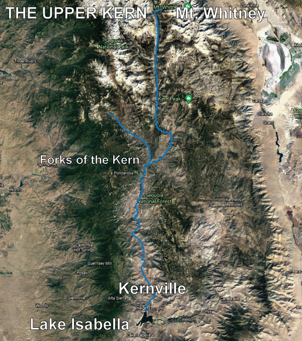
Upper Kern & Forks of the Kern
The Kern begins in the Sierra Nevada in Sequoia National Park in northeastern Tulare County, near the border with Inyo County. The main branch of the river (sometimes called the North Fork Kern River) rises from several small lakes in a basin northwest of Mount Whitney. The Kern River flows due south through a deep glacier-carved valley, passing through Inyo and Sequoia National Forests and the Golden Trout Wilderness, and receiving numerous tributaries including Rock Creek, Big Arroyo, Golden Trout Creek and Rattlesnake Creek. After deviating briefly from its due south course as it flows east around Hockett Peak, it is joined by the Little Kern River from the northwest at a site called Forks of the Kern. This is the launch point for our backcountry, Class IV and V, Forks of the Kern Two and Three-Day trips. Downstream of this confluence, the Kern River continues south, and is joined by more tributaries including Freeman Creek, Durrwood Creek, Peppermint Creek, and Dry Meadow Creek. The Johnsondale Bridge designates the farthest upstream put-in for our Upper Kern trips. South Creek, Brush Creek, and Salmon Creek, which all form large waterfalls as they tumble into the Kern River Canyon downstream of the bridge. This 20-mile reach of river is where we run our Class III and IV Upper Kern and Class V Thunder Run trips.
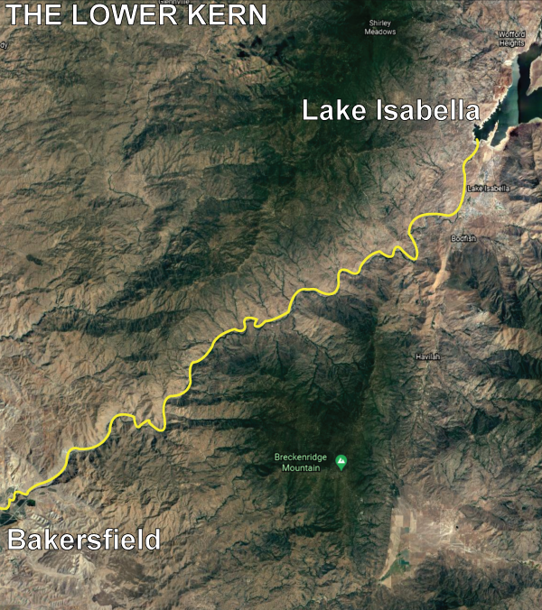
Lower Kern
At Kernville the river emerges from its narrow canyon into a wide valley where it is impounded in Lake Isabella, formed by Isabella Dam. The area was once known as Whiskey Flat, the former location of the town of Kernville. In Lake Isabella, it is joined by its largest tributary, the South Fork Kern River, which drains a high plateau area to the east of the North Fork drainage. The 95-mile (153 km)-long South Fork rises in Tulare County and flows south through Inyo National Forest, turning west after entering Kern County. Directly downstream from the Isabella Dam lie the starting points for our Lower Kern trips. This 20-mile reach of river offers outstanding Class III and IV One Day, 1/2 Day, and Multi Day Overnight trips. We maintain a beautiful, private, riverside campground for guests joining us on our overnight adventures.